The KHOU 11 weather team is watching what impacts the storm could have on the Texas Gulf Coast.
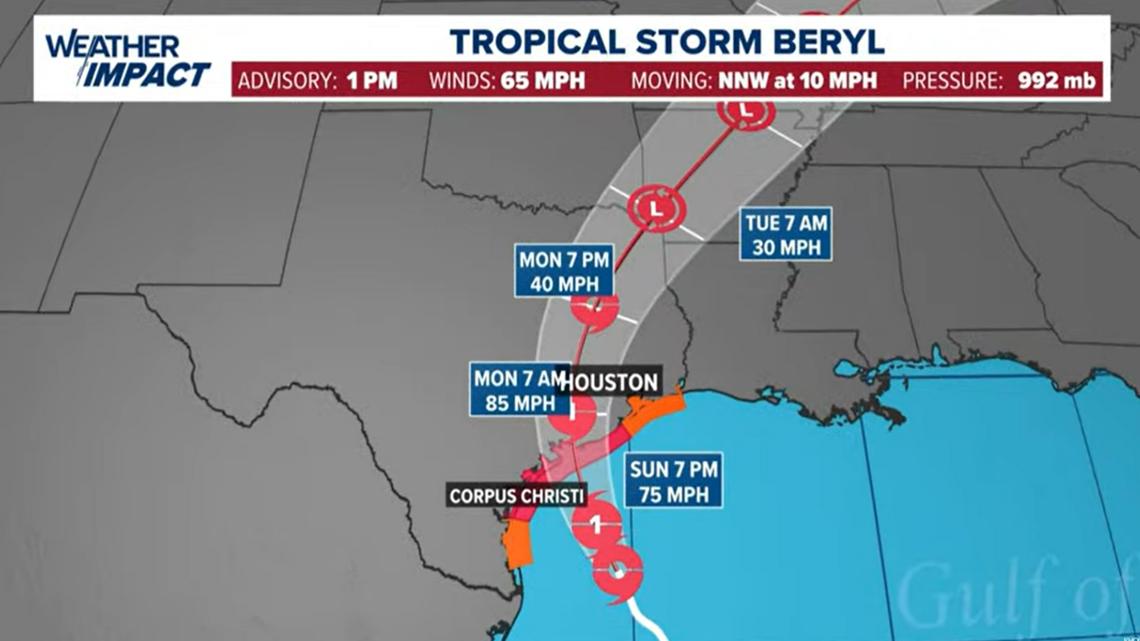
HOUSTON — With the 1 p.m. Sunday update, Beryl remained a tropical storm with winds at 65 mph as it headed toward the Texas coast. It’s heading northwest at 10 miles per hour. The KHOU 11 Weather Team is issuing a Weather Impact Alert Day for Sunday as Beryl approaches. Monday is also a Weather Impact Alert Day. The biggest impact will be between 1 a.m. and 1 p.m. on Monday. Tuesday was originally supposed to be a Weather Impact Alert Day, but it’s been removed as models show Beryl racing out of the Houston area and will be in North Texas by Tuesday morning.
Click here for Spanish coverage of Tropical Storm Beryl.
SPECIAL TROPICAL STORM BERYL COVERAGE: KHOU 11 will have coverage of Tropical Storm Beryl on air and online Sunday, We’ll be on KHOU.com, the KHOU 11 app and KHOU 11+ hourly with the latest updates on the storm. Download the KHOU 11 app and we’ll alert you when we’re going on.
Beryl’s wind speed increased slightly on Sunday. Winds were sustained at 65 mph and the storm was moving northwest at 10 mph. Beryl continues to fight off nearby dry air and wind shear, but conditions are expected to become very favorable for strengthening into the afternoon. As a result, the National Hurricane Center (NHC) still expects Beryl to reach Category 1 status Sunday afternoon before making landfall somewhere along the middle of the Texas Coast.
Watches and warnings

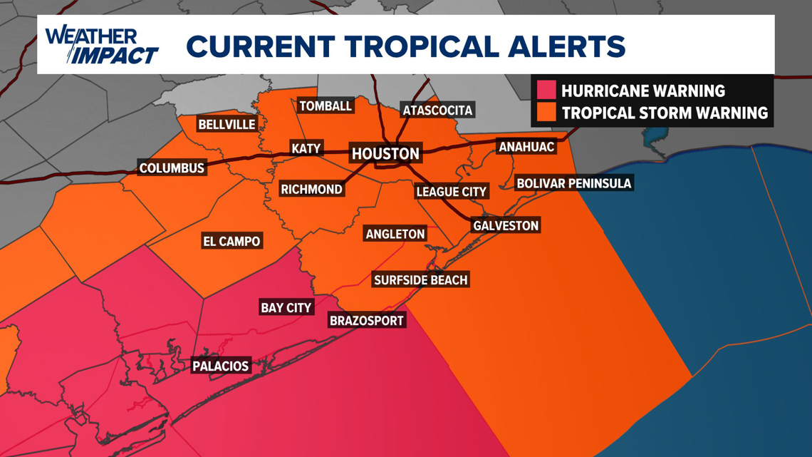
Tropical Storm Warnings are now in effect for ALL of Harris, Austin, Waller, Fort Bend, Galveston, Chambers, Brazoria, Colorado, and Wharton counties until further notice. A Hurricane Warning remains in effect for Matagorda County.
Rain bands capable of producing some localized flooding are possible on Sunday, along with the chance for a few tornadoes. As the storm moves onshore Monday morning, heavy rain and tropical storm force winds will be possible across the area, especially for locations west of the City of Houston. Rain totals averaging five to 10 inches are possible, with locally higher amounts. The most significant rain totals are expected during the day on Monday. The rain will be intermittent, but localized and intense tropical bands moving north from the Gulf will be the primary concern for flash flooding during the day. As a result, NOAA has placed areas from Houston and points west under a level 3 out of 4 for flash flooding risk on Monday.
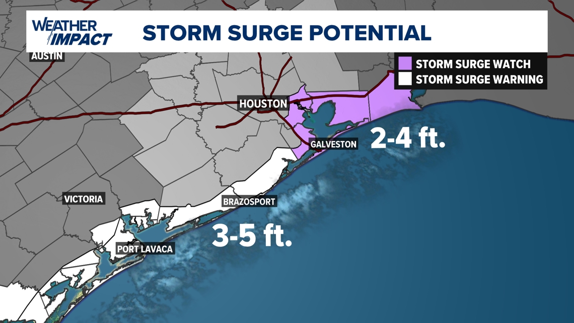
Storm Surge Warnings are now posted for the upper Texas coast, including Galveston, for storm surge values of 3 to 5 inches in Galveston and 4 to 6 inches down the coast closer to landfall.
Beryl 1 P.M. statistics
With the 1 p.m. Sunday update, Beryl was a tropical storm with maximum sustained winds of 65 mph, moving northwest at 10 mph. National Hurricane Center advisory in Spanish.
Live tropical tracker
Beryl forecast cone

Be prepared

Disaster declaration


There are now more than 120 Texas counties under a disaster declaration, including Harris, Ft. Bend, Galveston, Brazoria, Montgomery and more. You can see the full list of counties here.
Evacuations
A voluntary evacuation was called for residents in coastal areas of Matagorda County.
Record-setting Beryl
The 2024 Atlantic Hurricane Season was promised to be an active one, with Colorado State University and NOAA predicting well above normal numbers. In fact, the NOAA forecast for the season was the most aggressive forecast ever produced. Several factors including record warm sea-surface temperatures and a transition to La Nina by late summer were the driving factors in these aggressive forecasts. However, Hurricane Beryl is already shattering records before the peak of the season arrives. Meteorologist Pat Cavlin has a list of records the storm has already broken.