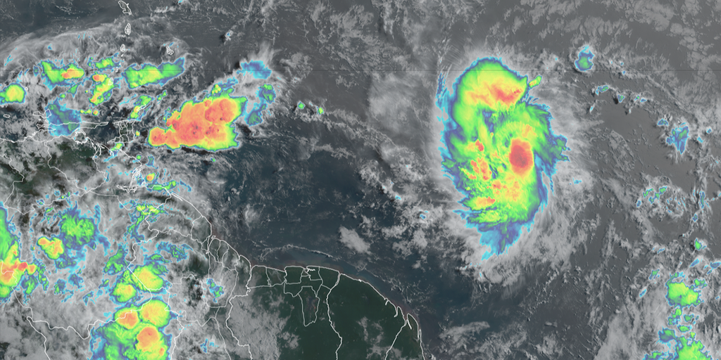
Tropical Storm Beryl has formed east of the Caribbean islands in the tropical Atlantic, and it’s expected to strengthen into a hurricane as it heads west in the days ahead.
Tropical Storm Beryl is now forecast to become a “dangerous” major Category 3 hurricane as it moves through the Windward Islands early Monday morning, the National Hurricane Center (NHC) warns.
At last report from the NHC, the cyclone had maximum sustained winds of at least 65 mph but is strengthening quickly. The cyclone will be classified as a hurricane once sustained wind speeds reach at least 74 mph, which is expected to occur by Saturday night or Sunday. But the storm isn’t expected to stop at 74 mph.
“Rapid strengthening is now forecast, and Beryl is expected to become a major hurricane before it reaches the Windward Islands,” the NHC said in its 11 a.m. ET advisory.
2024 ATLANTIC HURRICANE SEASON GUIDE: HERE’S WHAT TO KNOW ABOUT THIS YEAR’S STORMS
Where is Tropical Storm Beryl?
Tropical Storm Beryl is located in the tropical Atlantic just over 800 miles east-southeast of the Windward Islands.
On its current trajectory, the cyclone is expected to impact southern parts of the Windward Islands starting later Sunday into Monday.
WHERE ARE THE LESSER ANTILLES, WINDWARD ISLANDS AND LEEWARD ISLANDS

(FOX Weather)
BERYL TRACKER: LIVE FORECAST, TROPICAL WEATHER ALERTS, SPAGHETTI MODELS AND MORE
What is the forecast for Tropical Storm Beryl?
Tropical Storm Beryl is expected to continue strengthening and soon become a hurricane before impacting the Caribbean.
Hurricane Watches have been issued for Barbados, St. Lucia, Grenada and St. Vincent and the Grenadines with Tropical Storm Watches in effect for Martinique and Tobago. Additional watches and warnings likely coming for the Windward Islands later Saturday.

(FOX Weather)
On its forecast trajectory, islands such as Barbados, Grenada, Saint Lucia, Martinque and Saint Vincent and the Grenadines will receive direct impacts from the storm.

(FOX Weather)
Tropical storm-force winds are likely along the affected islands by Sunday with hurricane-force winds likely Sunday night or Monday morning, according to the NHC.
The latest forecast from the NHC now shows winds reaching upwards of 115 mph – rating a Category 3 on the Saffir-Simpson Scale – as the cyclone moves through some of the islands.
Beryl is not a large storm, so a slight deviation in its track changes which islands get what impacts.
“This is a confluence of unusual events for June,” said FOX Weather Hurricane Specialist Bryan Norcross. “The storm is tracking at an uncommonly far south latitude, which is allowing it to avoid the Saharan dust plume and cooler water to the north. The atmospheric pattern it will traverse over the next two days is forecast to be extremely conducive to tropical development – again unusual for June.”
In addition to hurricane-force winds, torrential rains will drench the islands. Current forecast totals predict Beryl will bring 3-6 inches of rain across Barbados and the affected Windward Islands, producing localized flooding.
The NHC has upgraded its storm surge forecast, now predicting a “life-threatening” surge that will raise water levels by as much as 5 to 7 feet above normal tide levels in areas of onshore flow in the Hurricane Watch area. Near the coast, the surge will be accompanied by large and destructive waves.
Heavy swells from Beryl are likely to create life-threatening surf and rip currents along the island chain.
The first hurricane of the season usually doesn’t come until Aug. 11.
Will Beryl impact the U.S.?
The closest American territories to the storm are the U.S. Virgin Islands and Puerto Rico, and neither is under a watch.
The FOX Forecast Center expects the main impacts to remain south of the islands; however, a passing band of showers cannot be ruled out.
It is too soon to tell if the hurricane will ever threaten the continental U.S., but if it does, it will likely be in a different form.
“After Beryl tracks into the Caribbean, the forecast becomes fuzzier. Could it eventually track into the Gulf? Yes, said FOX Weather Hurricane Specialist Bryan Norcross. “Although it’s not worth thinking about. There are too many variables in play.”

(FOX Weather)
WHY THE EASTERN CARIBBEAN IS KNOWN AS THE ‘HURRICANE GRAVEYARD’
Norcross adds that the consensus at the current time is that Beryl will weaken when it reaches the central and western Caribbean as it moves away from the pristine atmospheric bubble over the eastern islands.
Tracking disturbance east of Beryl & Invest 94L around Central America
A disturbance a couple of hundred miles east of Beryl is producing disorganized showers and thunderstorms.
Some slow development of this system is possible early next week as it moves generally westward across the central and western tropical Atlantic at 15 to 20 mph, according to the NHC.
It currently has a medium chance of development over the next week and could take a similar track as Beryl.

(FOX Weather)
Another disturbance dubbed Invest 94L is moving through the Caribbean toward Central America and southern Mexico, bringing heavy rainfall.
The NHC is giving this system a medium chance of developing. If it does, it would likely be in the far western Caribbean or the extreme southern Gulf of Mexico if the system survives its trek across land.


