Severe flooding across South Florida has triggered at least one water rescue, damaged homes, stalled cars, prompted response from officials, canceled classes and even stranded cats in trees on Thursday after storms soaked the region in up to 20 inches of water. And the rain isn’t done yet.
A flood watch remains in effect for all of South Florida into Friday. But it won’t take much to trigger further warnings. See all weather alerts here.
Here’s what you need to know.
https://x.com/NWSMiami/status/1801194031302783424
How much rain are we talking about?
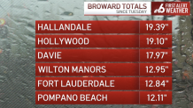
Hallandale and Hollywood in Broward County have seen the highest rainfall count so far with over 20 inches since Tuesday. In Miami-Dade, North Miami also came in at more than 20 inches of rain.
First responders have worked at least one water rescue in North Miami, as officials respond to power outages and stalled vehicles in roads that resemble rivers.

Emergency declarations
Gov. Ron DeSantis declared a state of emergency Wednesday for Miami-Dade, Broward, Collier, Lee and Sarasota counties, due to the heavy rain that inundated the area.
Miami-Dade Mayor Daniella Levine Cava also declared a state of emergency for the county, while Fort Lauderdale Mayor Dean Trantalis and Miami Mayor Francis Suarez made declarations for their cities.
Parts of Miami-Dade and Broward were under a rare flash flood emergency, which means the National Weather Service was reporting extremely heavy rain that is causing a severe threat to human life and catastrophic damage.
Closures
- Florida International University has closed its Biscayne Bay and I-75 campuses until further notice
- Broward County Public Schools are closed
- Dania Beach City Hall is closed, except for the City Clerk’s Office for election-related business
- City of Miami Parks and programming, including summer parks, will be closed
Sandbags
Opa-locka
- Thursday, June 13 until 7:00 p.m. and Friday, June 14 from 8 a.m. to 7:00 p.m. at the City of Opa-locka Public Works Department
Miami Beach
- Drive-through distribution sites will be located on the surface lots at 2111 Collins Avenue and 225 79 Street on June 13 and 14 from 12 p.m. until 4 p.m.
- These locations have a machine that fills sandbags and there is a limit of 4 per household.
Residents can get sandbags by proving that they reside in the area. There are limits to how many sandbags per household are allowed.
Travel impacts
Brightline
The following were suspended due to flooding:
- service between Miami and Fort Lauderdale
- northbound trains from Miami and Aventura
Fort Lauderdale will be the final destination for southbound trains.
Miami International Airport
The severe thunderstorms canceled 71 arrivals and 65 departures at MIA, Miami-Dade Aviation Department Communications Director Greg Chin said.
Fort Lauderdale-Hollywood International Airport
According to flight tracker FlightAware, there were 28 delays and 39 cancelations at FLL.
Forecast
The region measured rainfall by the foot Wednesday afternoon as tropical downpours drenched both counties.
Through midnight, Hollywood Beach recorded over 14 inches of rain while Surfside tallied over 12.
This led to flooding from Fort Lauderdale to Aventura, with impacts extending on either side of U.S. 1.
While showers tapered off overnight, the risk for additional flooding continued Thursday as the forecast pattern changes very little. An additional 1 to 2 inches of rainfall are possible, with additional downpours to continue through Friday.
NBC6’s Adam Berg has your forecast for today, Thursday, June 13, 2024.
A flood watch remains in effect through Friday as any additional rainfall may induce additional flooding due to saturated ground.
This soggy stretch of weather is due to a combination of passing disturbances producing lift in the atmosphere.
This, paired with and a seemingly limitless supply of tropical moisture running over the area, has delivered multiple days of flooding rainfall.
Looking ahead, a slightly drier trend will unfold for the weekend, allowing for lower storm chances and more sunshine.