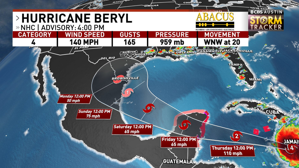
Wednesday July 3 | 4 p.m. Update
Beryl continues to bring life-threatening storm surge and hurricane-forced winds to Jamaica as the eye of the hurricane is located along the southern shore.
It remains a Category 4 with max sustained winds of 140 mph as it continues to quickly move west-northwest at 20 mph.
Hurricane warnings are out for the Cayman Islands as it will move close there on Thursday.
The National Hurricane Center forecast it to weaken some as it moves near the Yucatan Peninsula early Friday, then emerge back over the ocean waters into the Gulf of Mexico late Friday into Saturday.
Land interaction would potentially weaken the storm to tropical storm status before strengthening once again into a potential hurricane before landfall somewhere near the Mexico/Texas coast Sunday into Monday.
A reminder that this is a fluid forecast and this will continue to change. If you live along the Texas coast, continue to frequently check back with the latest forecast. We’ll know more on where Beryl could be heading over the next couple of days.
Wednesday July 3 | 1 p.m. Update
Beryl has weakened some Wednesday afternoon as it now has 140 mph sustained winds, but still is a category 4.
The center of Beryl is currently just around the southside of Jamaica bringing hurricane-force winds to the island for the the rest of the afternoon and evening.
The National Hurricane Center still has Beryl as a major hurricane through Thursday before interacting with more wind shear that will weaken it even more as it approaches the Yucatan Peninsula by Friday.
Hurricane warnings and watches our out for the eastern side of the Peninsula and a tropical storm watch is now our for the northern and western side.
It will likely make landfall Friday morning as a hurricane before moving into the Gulf of Mexico Friday night into Saturday. As of Wednesday afternoon, the forecast cone includes portions of south and south-central Texas by late Sunday into Monday.
Beryl is still forecast to strengthen back into a hurricane on its approach to either Mexico or Texas. Still too early to determine if and exactly where/how Beryl could impact Texas.
If you live along the Texas coast, continue to frequently check back with the latest forecast. We’ll know more on where Beryl could be heading over the next couple of days.
Wednesday July 3 | 10 a.m. Update
Hurricane Beryl continues its journey through the Caribbean as a powerful Category 4 hurricane.
Beryl is expected to impact Jamaica Wednesday as hurricane warnings are out for the island in preparation for hurricane-force winds today.
It will then start to impact the Cayman Islands on Thursday before approaching Cancun/Yucatan by late Thursday into Friday. A hurricane watch is now out for the eastern side of the Yucatan Peninsula.
BERYL IN THE GULF OF MEXICO
After Beryl moves through the Yucatan Peninsula, it is forecast to move into the Bay of Campeche/Gulf of Mexico by Saturday.
Due to land interaction, it is expected to weaken to a tropical storm. Due to the warm waters in the Gulf and potentially less wind shear, Beryl is expected to strengthen some as stays over the open water.
By the late weekend, the National Hurricane Center is calling for it to re-strengthen into a hurricane as it approaches either Mexico or potentially the Texas coast.
POTENTIAL IMPACTS TO TEXAS?
Now, we are still a couple of days away from this system moving into the Gulf of Mexico and even several days from the system potentially moving into Mexico or even Texas. We’re watching the latest trends very closely that bring Beryl closer to Texas Sunday into Monday.
Latest trends continue to show Beryl curving further north near the Texas/Mexico border rather than moving just into Mexico. If this were to happen, it would have more time over the warm, Gulf of Mexico waters potentially allowing it to strengthen even more.
A stronger system could mean a further north track that could bring bigger impacts to the Texas coast. Impacts would be coastal flooding from storm surge, potential strong wind gusts and torrential tropical rainfall that could lead to inland flooding. Impacts could be far enough to impact portions of Central Texas with rain and gusty winds.
If it has a rougher time over the Yucatan Peninsula, it might be impacted enough to just move further west into Mexico bringing less impacts to Texas.
We still have more questions than answers this far out, but Texans along the coast need to consistently check forecast updates throughout the week.
HOW TO STAY WEATHER AWARE
Download the CBS Austin Weather App for the latest weather updates and information here.
Check here for more CBS Austin Weather forecast updates.