Exclusive FOX Storm Trackers Vince Waelti and Brandon Copic both have live views of a tornado tearing through Iowa.
DES MOINES, Iowa – A series of large, violent tornadoes struck the Hawkeye State on Tuesday, causing significant destruction in some rural communities.
Portions of Iowa, northwest Illinois, southeast Minnesota and western Wisconsin were placed under a “Particularly Dangerous Situation” Tornado Watch h as rounds of powerful storms raced across the area, continuing a dayslong severe weather threat for several parts of the U.S.
Less than 5% of all severe weather watches are given the Particularly Dangerous Situation tag.

(FOX Weather)
A violent tornado tore through central Iowa on Tuesday causing destruction in the town of Greenfield. Drone video showed several structures that were leveled and residents working to find storm victims.
At least one death was attributed to the storms in Iowa.
A resident is believed to have been killed as a supercell raced through Corning in Adams County.
A tornado was spotted outside of Red Oak, Iowa on Tuesday.
Tornadoes spotted in Iowa
At least half a dozen tornadoes were spotted over western and central parts of the Hawkeye State on Tuesday afternoon.
Tornadoes were reported in Red Oak, Carbon, Corning and Greenfield, where damage was reported to power lines, wind turbines and homes.
At least one wind turbine was on fire and lying propped against the ground in Prescott, Iowa, which is southwest of Des Moines.
The FOX Forecast Center spotted debris on radar from two twisters that impacted Carbon and Corning and debris was being reported thrown at least 15 miles from a tornado that impacted Greenfield, Iowa.
Greenfield has a population of around 2,000 people and is the heart of Adair County, Iowa.
Video showed people searching through rubble from what was a large tornado. Due to the powerful display on radar, forecasters believe the twister was on the upper half of the Enhanced Fujita Scale Wind Scale.
Damage appeared to be significant on the south and east sides of Greenfield around where the region’s medical center sits.
“Most of this town is gone…There’s no other way to put it. Most of this town’s gone,” said FOX Weather Exclusive Storm Tracker Brandon Copic.
PowerOutage.us reported more than half of Adair County was without power following the severe storms.
MONSTER TORNADO DEVASTATES GREENFIELD, IOWA: ‘MOST OF THIS TOWN IS GONE’
Storm Tracker Brandon Copic is one of the first on the scene to witness the tornado damage in Greenfield, Iowa.
Roads into and out of Greenfield were blocked by first responders in the hours after the severe weather to keep nonresidents out of the community.
“So it came up pretty quickly. The storm was moving at 50 to 55 miles an hour. So they’re coming in quickly. People had a decent warning…And, thankfully, 99% of the people that we had talked to had a good reaction to that warning and took shelter,” said Copic.
Parts of the Des Moines metro were also put under a Tornado Warning on Tuesday afternoon.
A wind gust of 71 mph was reported east of Des Moines at the Newton Municipal Airport.
Outside of the severe storms, a Dust Storm Warning was issued for Central Illinois due to reduced visibilities around Champaign and Decatur.
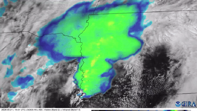
Satellite animation of supercells rolling through Iowa on 5/21/2024
More dangerous storms Wednesday-Thursday
The line of storms will continue into Wednesday, stretching from the eastern Great Lakes down to the Plains.
The FOX Forecast Center said details are still unclear on how Wednesday plays out, but ingredients are in place for at least a day of damaging wind gusts and large hail. The highest threat of severe weather will extend from North Texas to the Missouri Bootheel.
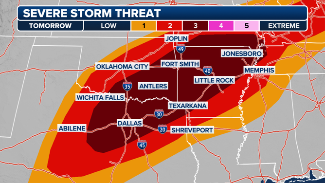
Wednesday severe weather threat