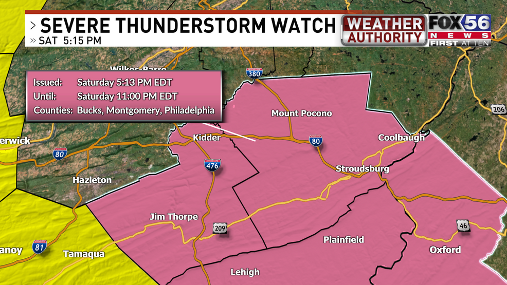
June 29, 2024 — The National Weather Service has issued a SEVERE THUNDERSTORM WATCH for Carbon & Monroe counties until 10 PM Saturday, June 29, 2024.
Strong/severe thunderstorms are possible across the area on Saturday evening. Strong damaging wind gusts, locally heavy rain, frequent lightning, and an isolated tornado are all possible. Some areas may also receive small, non-severe hail.
A severe thunderstorm watch means severe thunderstorms are POSSIBLE. They have not necessarily developed yet. If a severe thunderstorm develops and is heading towards you, a warning will be issued by the National Weather Service.
Here is a look at the alert bulletin from the National Weather Service’s Storm Prediction Center:
————————————————————————————————————————————————————————————–
Carbon & Monroe counties (until 10 PM Saturday)
URGENT – IMMEDIATE BROADCAST REQUESTED
Severe Thunderstorm Watch Number 484
NWS Storm Prediction Center Norman OK
455 PM EDT Sat Jun 29 2024
The NWS Storm Prediction Center has issued a
* Severe Thunderstorm Watch for portions of
Western New Jersey
Eastern Pennsylvania
* Effective this Saturday afternoon and evening from 455 PM until
1100 PM EDT.
* Primary threats include…
Scattered damaging wind gusts to 70 mph possible
A tornado or two possible
SUMMARY…A line of thunderstorms moving eastward should pose some
risk for severe/damaging winds late this afternoon into the evening,
perhaps up to 60-70 mph.
The severe thunderstorm watch area is approximately along and 40
statute miles east and west of a line from 35 miles north of
Allentown PA to 30 miles west southwest of Philadelphia PA. For a
complete depiction of the watch see the associated watch outline
update (WOUS64 KWNS WOU4).
PRECAUTIONARY/PREPAREDNESS ACTIONS…
REMEMBER…A Severe Thunderstorm Watch means conditions are
favorable for severe thunderstorms in and close to the watch area.
Persons in these areas should be on the lookout for threatening
weather conditions and listen for later statements and possible
warnings. Severe thunderstorms can and occasionally do produce
tornadoes.
&&
OTHER WATCH INFORMATION…CONTINUE…WW 482…WW 483…
AVIATION…A few severe thunderstorms with hail surface and aloft to
1 inch. Extreme turbulence and surface wind gusts to 60 knots. A few
cumulonimbi with maximum tops to 500. Mean storm motion vector
27035.
…Gleason
————————————————————————————————————————————————————————————–
Stay tuned for more updates throughout the evening and be sure to catch your latest forecast tonight on FOX56 News at 10 PM!