In Nebraska, the National Weather Service office in Omaha said more storms could develop by Sunday morning and that the worst weather was expected Sunday afternoon. A hazardous weather statement for parts of Nebraska and Iowa warned that strong to severe thunderstorms may develop with wind gusts to 60 mph, hail up to the size of quarters “and a tornado or two.”
“We have yet another risk for severe weather today,” the weather service in Omaha posted on social media. “Keep an eye on the weather, especially if you’ll be outdoors.”

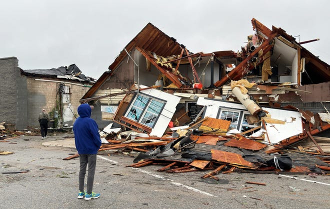
The National Weather Service in Des Moines said preliminary reports indicate at least 10 tornadoes struck central Iowa during Friday’s storm front, based on initial damage information. More damage could come on Sunday.
“Severe storms may develop (after 3 p.m.) with some uncertainty,” the agency said on social media. “If it does, large hail is the main threat, with damaging winds and a few tornadoes secondary threats.”
In Nebraska’s Douglas County, which includes Omaha, chainsaws buzzed as residents cleared debris. Sheriff Aaron Hanson lauded locals for their efforts but urged the curious to stay away to allow roads to be cleared and cleanup to continue.
“A tornado of this size hits major urban area causes major damage with no confirmed deaths or serious injuries, thousands of people turn out to help,” he said in a social media post. “Is this God reminding us that we need to be kinder to one another?”